I’ve been fortunate enough to hike the West Coast Trail twice; both times starting on the northern end, stepping off the gravel road near Bamfield and heading south into the long rhythm of tide and forest. From the moment you leave the parking lot, the trail reorganizes your attention.
Time stretches out to infinity. Weather becomes incredibly intimate. Every crossing, ladder, and headland must be negotiated on its own terms. That journey is only possible because of a single road – the winding route from Port Alberni to Bamfield, the only year-round land access to a small community perched at the edge of the Pacific.
Bamfield isn’t just remote; it’s dependent.
Food, fuel, mail, construction materials, and emergency services arrive along that road. When it closes, options narrow quickly. What looks like isolation on a map is, in reality, a fragile connection; one thin line threaded across steep slopes, logging roads, and river crossings, holding a community in place.
On August 11, 2025, that connection broke.
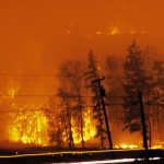
The Mount Underwood wildfire erupted south of Port Alberni during a stretch of hot, dry weather that still feels unfamiliar on Vancouver Island. Smoke settled into the valley and lingered, muting the sun and turning mornings into a dull, coppered dream. Ash drifted down in places far from the flames themselves. The fire spread rapidly, behaving less like the small, ground-hugging fires historically associated with the Island and more like the fast-moving, wind-driven fires now common in the Interior; fires like White Rock Lake, or the nearby Cameron Bluffs fire, where behaviour outpaced expectations.
Power lines went down, cutting electricity to Bamfield for nearly two weeks. Refrigeration failed. Communications were strained. Generators filled the quiet space. For a time, daily life narrowed to essentials. Then the road was knocked out.
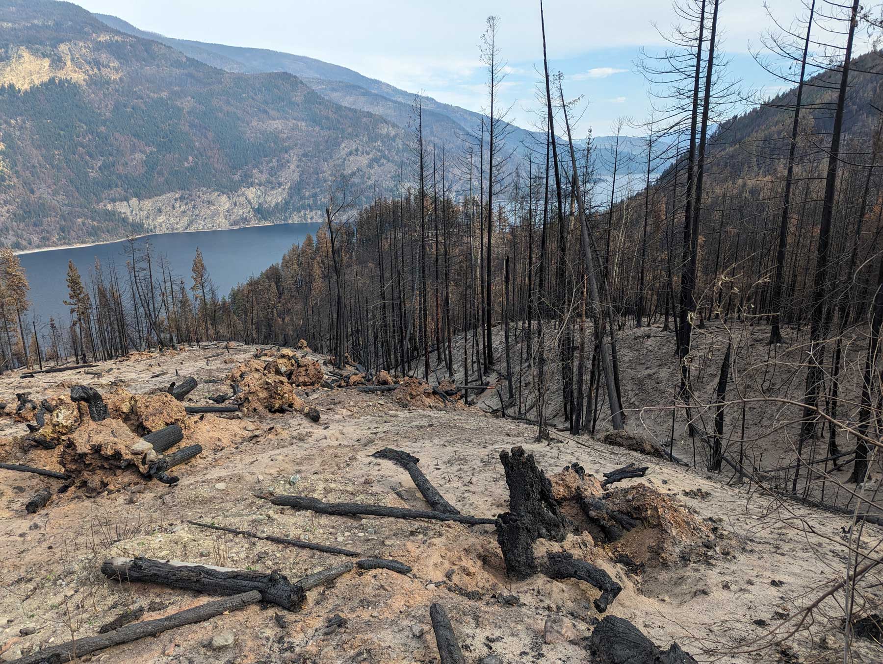
Fire stripped vegetation from steep terrain above Bamfield Main Road, destabilizing slopes that had already been weakened by decades of disturbance. The ground buckled and then collapsed, spilling out onto the asphalt. Rock and soil slid downslope and slammed the door shut. The connection to Bamfield was closed.
Infrastructure emergency
What began as a wildfire response became an infrastructure emergency. Bamfield was no longer riding out a power outage; it was physically cut off. The closure would last into October, more than two months after the fire was first discovered. During that time, supplies arrived by boat when weather allowed. Plans were revised daily. The vulnerability that underpins life in coastal communities was suddenly exposed, like the raw earth revealed when the hillside gave way.
All this takes place on the unceded territories of the Nuu-chah-nulth Nations, where forest stewardship long predates the modern logging economy. Traditional management included selective harvesting and cultural burning to reduce fuel loads and maintain ecological balance.Those practices were lost when the land was taken.
The vulnerability that underpins life in coastal communities was suddenly exposed.
Fires of this size and intensity were not historically common on Vancouver Island, with the exception of several major burns in the early twentieth century. Those were tied to logging practices of the time: clearcutting large tracts, removing the most valuable species, and leaving dense mats of slash behind to dry. Fire, when it arrived, moved quickly through these altered landscapes.
Still, the Mount Underwood fire did not feel like a relic of the past. It felt like the future arriving. It behaved like the fires that now define summers elsewhere in the province – fires that escalate rapidly, defy early expectations, and interact with infrastructure in unpredictable ways. It is increasingly difficult to treat such events as anomalies. They are signals, early arrivals in a landscape that is changing faster than its systems were designed to absorb.
Impacts of logging
Port Alberni sits at the centre of that changing landscape. Like many towns on Vancouver Island and across British Columbia, it was built on forestry. The surrounding valleys have been logged for generations, shaping not only the local economy but also the terrain itself. Roads carve deep into watersheds. Slopes are cut, replanted, and cut again. Municipal tax bases, employment, and identity have long been tied to what comes in off the hillsides. These forests are no longer simply ecological systems. They are working landscapes, and that distinction shaped what happened next.
The Mount Underwood fire burned largely on privately managed forestland owned by Mosaic Forest Management, one of the largest forestry companies on Vancouver Island. The area has been actively logged for decades and consists of a collection of second-growth plantations, recent cutblocks, roads, and remaining patches of older forest.
Western Forest Products took over the logging rights in 2005 from Weyerhaeuser, formerly MacMillan Bloedel, which started logging the valley in 1955.
That history mattered when the fire arrived. Removing forest cover increases erosion, raises water temperatures, and alters how water moves across the land. It also heightens the risk of slope failure.
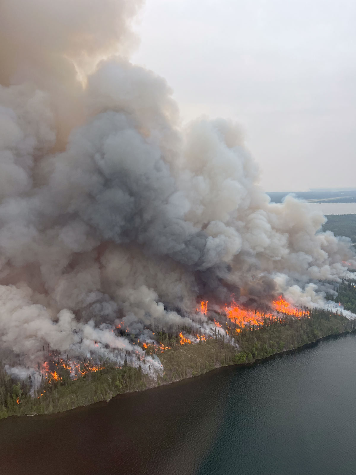
Photo by the National Interagency Fire Center
During the Mount Underwood fire, those risks converged. Fire stripped vegetation from steep terrain already heavily marked by forestry roads and cutblocks. When rain followed, it did not soak slowly into the forest floor; it ran. Slopes failed and slid down to the highway. The fragile road connection collapsed.
The rain should have been a relief. It became a second emergency layered atop the first like the shifting layers of the soil perched above the road itself.
The slide and its impacts didn’t stop at the highway. Sediment moved downstream into creeks and estuaries. For fish populations already under pressure, these changes carry serious consequences. Salmon, which depend on cool, clean spawning habitat, are particularly vulnerable.
When watersheds are destabilized, the impacts ripple outward into ecosystems, into fisheries, and into the food systems that coastal communities rely on. As controversial as it is, logging is still ongoing in the Nahmint Valley watershed, which supplies Port Alberni with much of its drinking water.
In places like Bamfield, a closed road is not merely an inconvenience. It changes how medical care is assessed, how food is stored, how long help takes to arrive. It exposes how thin the margin is between connection and isolation.
As fires grow larger and landscapes change, it’s worth asking how secure those connections really are, and what resilience looks like in places built at the edge of both geography and economy. Sometimes, the distance between community and isolation isn’t measured in drive times or policy debates.
Sometimes, it’s just a three-metre-wide track.
Ben Wickham is a writer from Nanaimo, BC with a background in education and public service.