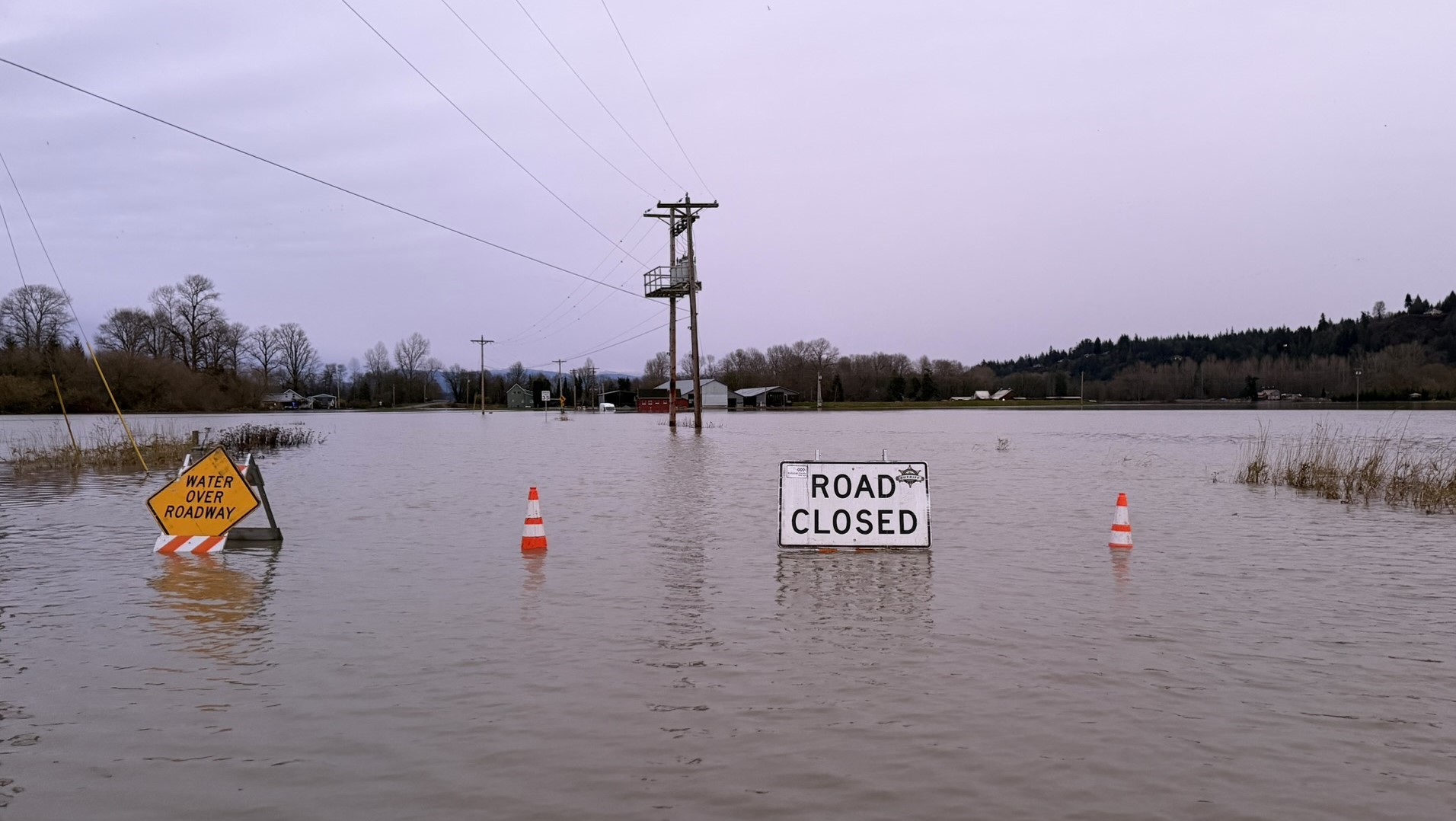
When floodwaters surged over the banks of Dove Creek and Tsolum River in the Comox Valley recently, roads buckled, culverts failed, and hundreds of acres of Vancouver Island farmland disappeared beneath brown water.
The flood caused devastating property damage and the evacuation of hundreds of residents and farm animals. A few hours north, the only highway connecting the town of Gold River with the rest of the world fell away under a torrent of water from the hillside above. The washout severed a vital lifeline to coastal communities, isolating residents and disrupting the transport of critical supplies.
Both events were triggered by an atmospheric river – a phenomenon that climate scientists say we should expect to see more often in coming years.
A torrent of costs
The frequency of flood events like these has increased over the last decade, with staggering financial impacts. According to the Insurance Bureau of Canada, flood events in the Fraser Valley in 2024 resulted in $74 million in damages.
But that total pales in comparison to the flood damage in 2021. That year, extreme rainfall overflowed creek beds and gushed down mountainsides, creating a muddy torrent that flooded every major route between the Lower Mainland and the rest of Canada. It submerged Fraser Valley farms under three feet of contaminated water. The resulting damages added up to $8.7 billion. Of course, the costs to families and workers who lost their homes and/or livelihoods is incalculable.
Rain falling on clearcuts
It’s not just rainfall that determines the scale of destruction. In a province shaped by steep terrain, intense precipitation, and a century of industrial forestry, hydrologists are examining the role of clearcut logging on the severity of flood events.
Clearcut logging is not new; it’s been the preferred harvesting method in BC forests for over a century. However, both atmospheric rivers and clearcut harvest areas have expanded significantly in the last 20 years. In 2005, the typical cutblock was 20-30 hectares. By 2020, commercial clearcuts ranged from 350 to over 3,000 hectares. Evidence suggests that depending on slope orientation, these larger cutblocks correlate with increased frequency and scale of catastrophic flooding.
Emerging research
Forest management practices play a much bigger role in flood events than previously considered, according to a 2025 study led by UBC forest hydrologist Dr. Younes Alila that examined long-term streamflow records in coastal BC watersheds. In addition to changing climate conditions, researchers looked at factors such as cutblock size, slope orientation, and historical data on watershed hydrology and flooding.
“This research challenges conventional thinking about forest management’s impact on flooding,” Dr. Alila said. “It matters not only how much forest you remove, but also where, how, and under what conditions.”
Should the public continue to absorb the financial consequences of flooding?
Conventional flood models rely on the simple assumption that when X per cent of trees are cut, there will be Y per cent more water runoff. The UBC study found that such models fail to account for extreme and erratic flood patterns that emerge after landscape disturbances.
Forest harvesting doesn’t just increase average flood levels – it can reshape a watershed’s entire hydrological system, making rare catastrophic flood events much more common. The most concerning finding is that this effect lasts for more than 40 years as forests rebuild their water retention and filtering ability.
Slope orientation surprise
“We found seemingly minor landscape factors, like the direction a slope faces, can make or break a watershed’s response to treatment,” said the study’s first author Henry Pham, a doctoral student in UBC’s faculty of forestry.
Their research found that slope orientation has a significant impact on how watershed basins shed water, particularly after cutblocks are harvested. While the impact of landscape disturbance is negligible after cutblocks are harvested on south-facing slopes, north-facing watersheds receive less direct sunlight and retain more moisture. Clearcuts on north-facing slopes were connected to floods becoming 4 to 18 times more frequent. Average flood sizes increased by 47-105% in these areas.
When forests are removed
Healthy mountain forests act as hydrological regulators, filtering and directing water into natural watershed routes. Tree canopies intercept rainfall. Root systems stabilize slopes. Healthy soils absorb and slowly release water, reducing the speed and volume of runoff entering streams.
When forests are extensively clearcut, particularly on steep terrain, several changes occur:
• Root decay results in soil erosion, reducing slope stability
• Soil compaction from heavy machinery reduces infiltration
• Road networks interrupt natural drainage routes
• Evapotranspiration (water surface eva- poration + soil moisture evaporation + plant transpiration) is reduced
Cumulatively, these processes disrupt how water moves over and through a watershed, resulting in greatly increased streamflows when extreme rainfall occurs.
A disturbed landscape
The recent Comox Valley flood provides a sobering example of how disruption of natural drainage systems can combine with extraordinary rainfall to cause widespread damage on both a public and private level. As a single event, it flooded homes, waterlogged agricultural lands, and damaged roads and culverts.
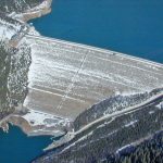
The upper watershed feeding the valley has been shaped by decades of forestry activity, including clearcut harvesting and road construction on steep slopes. Progressively dated photos on Google Earth reveal the removal of thousands of hectares of forested area on adjacent mountainside over the last 20 years.
While no single cutblock can be blamed for a flood, cumulative watershed disturbance may alter how quickly water moves downhill during intense storms. Municipal officials now estimate that recovery and infrastructure repair costs run into the millions. These costs are borne by taxpayers.
Vulnerable infrastructure
When a section of highway near Gold River washed out, it cut off access to remote Vancouver Island communities and halted traffic for days. Debris flows and saturated slopes overwhelmed culverts and destabilized embankments. Steep coastal terrain is inherently prone to landslides during extreme rainfall. But road density and altered drainage patterns compound that risk. Satellite photos from Google Earth show a recent clearcut stretching for hundreds of hectares across the steep mountainside directly above the Gold River Highway washout.
In remote communities with limited infrastructure redundancy, a single washout can disrupt emergency response, supply chains, tourism, and local economies. Again, reconstruction is funded publicly.
Governance and cumulative effects
British Columbia’s forestry framework regulates individual cutblocks, reforestation obligations, and environmental protection measures. However, critics argue that cumulative hydrological impacts are not properly integrated into planning decisions. Hydrological thresholds, such as limits on total disturbed area within a watershed basin, are not uniformly applied. Road deactivation and slope stabilization efforts vary.
Indigenous-led stewardship models in some regions emphasize watershed integrity as a primary management objective. Such models offer alternative governance approaches that prioritize long-term hydrological resilience over short-term timber yield. With the existing climate pattern of intensifying extreme rainfall events, cumulative effects matter more than ever.
Land-use policies
Extreme floods are fundamentally driven by meteorological forces. Atmospheric rivers will continue to bring intense rainfall to forests and clearcuts alike. However, there is little doubt among hydrologists that cutblock orientation and size contribute to the frequency and intensity of flooding. Land-use policies must take this into account as as part of emerging climate-change adaptation strategies.
Treating mountain forests as timber supply areas no longer aligns with evolving climate realities. Incorporating watershed resilience into forest planning – through harvest limits in sensitive basins, road decommissioning, and protection of high-
functioning forest stands – could reduce long-term public costs. Clearly, such measures won’t eliminate flooding altogether. But they are likely to reduce the frequency and scale of floods.
“As climate conditions shift, understanding those dynamics is becoming increasingly important,” Dr. Younes Alila said. “We hope industry and policymakers will take note of our findings, which show that it matters not only how much forest you remove but also where, how, and under what conditions.”
How much risk is too much?
Current climate models leave no doubt that storms will continue to intensify. However, we have the power to change how watersheds are managed before the next atmospheric river arrives.
This brings up an unavoidable policy question. Should the public continue to absorb the financial consequences of flooding? Presently, taxpayers and insurance policy holders foot the bill for flood damage, while forest management companies continue to rake in profits from Crown lands. In a province where coastal geography is defined by mountains, rain, and forest, there’s no debate about whether storms will come. It is about whether we will continue to intensify their impact by failing to adopt forest management practices that address this fact.
Lynne Fedorick is a Canadian journalist and freelance writer whose work has been featured in a variety of international magazines.